Sunday, February 06, 2011
GIS and ecology


Thursday, January 20, 2011
Landscape Ecology of the Palmer Divide
Black Forest is at a four-way crossroads of the plains and the mountains, as well as the northern and southern Great Plains. The Black Forest is a mix of species such as Douglas fir, white fir, ponderosa pine, pinon pine, junipers, gambel oak, and relict tallgrass prairie. In her thesis, she looks at the geology, geomorphology, climate, soils and vegetation of the area to build a landscape ecology of the Palmer Divide.
She also throws in some ordination graphs, and uses computer programs like DECORANA and CANOCO, which at this point are beyond me. However, I got some good information I could take away.
Soil parent material and particle size (and their water holding capabilities) follow vegetation communities pretty closely.
- Northern mixed grass prairie is linked with eolian (wind blown) sand dunes and sandy alluvium
- Shortgrass prairie likes warm, clayey, alkaline (high Ca++ and Mg++ levels) soils
- Coniferous forest seems to be found more on weathered Pikes Peak granite and arkosic (high feldspar content, eroded sandstone) residuum of the the Dawson formation, in areas of higher moisture
- Douglas fir is found on steep (>20%), north-facing slopes where snow lingers longer
- Pinyon-juniper shows up in south or southeast facing slopes in soils with high clay content
- Gambel oak which grows by itself in grassland experiences less frequent and less intense fires than oak that grow in ponderosa pine.
- Grazing has altered the fire regime of the region
- Tallgrass prairie appears on arkosic alluvium and clay-silt soils. Little bluestem and prairie dropseed are found in cooler areas as opposed to mountain mahogany shrubland, which appears in warmer areas with sandy clay.
- Areas a few miles apart have different moisture seasonality. The south side of the divide and the highest elevation have a late summer moisture pulse, or monsoon, while the area north all the way to Castle Rock gets an earlier spring pulse of moisture, and not much a late summer monsoon.
I wonder if it would be possible to recreate 1. a pre-1860 fire regime, and 2. a description of the structure and age class of the forest at that time. Are there records of the timber volume extracted from the forest in the 1860s? Could one go backwards and recreate a forest based on this information, if it exists?
What would it take to reactivate the eolian dunes? How does thinning change the ecology of the forest, now that the fires are completely suppressed?
Tuesday, June 19, 2007
Ozone up again on the Front Range
Powered by ScribeFire.
New report on forest health in Colorado
You can download the report in a PDF (direct link) here.
***********************************************************************************
A new report gives the low down on the range of beetles devouring Colorado's conifers, as well as declining aspen.
Some 643,000 acres of lodgepole forest - about 42 percent of Colorado's total - were infested last year by mountain pine beetles, said Jen Chase, lead author of the 2006 Report on the Health of Colorado's Forests.
But the damage went beyond lodgepoles. Ponderosa pines also suffered from mountain pine beetles in 2006, along with:
• 138,000 acres of aspens declining from a mysterious affliction.
• 68,000 acres of spruce infested with bark beetles.
• 372,000 acres of subalpine fir attacked by Western balsam bark beetles, root diseases and other unknown factors.
• 19,000 acres of piñon pines infested with ips beetles.
• 93,000 acres of Douglas fir, true fir and spruce hit by Western spruce budworm.
As for the causes:
"A lot of these outbreaks got kicked off because of the drought, but forest conditions have allowed them to keep expanding," said U.S. Forest Service entomologist Bob Cain. "We have pretty uniform conditions of older, denser forests across the state, which are susceptible to the bark beetles," he said. "So even though the drought conditions have improved, the outbreaks are continuing."
Which sounds to me like he might be referring to those "decadent" old growth stands. I'm not convinced that any new logging regime is going to change this situation. From what I've seen, when the trees, living or dead, are logged, they come back in the same, dense, single age stands to which Bob Cain refers. And then we have a never ending cycle until the seed stock is gone.
Moreover, no reference to global warming in the article, which with warming temperatures has reduced the winter freezes that kept the beetles in check. Nothing to be done about that for a long time.
powered by performancing firefox
Wednesday, February 07, 2007
2006 El Niño fakes out Colorado forecasters
An El Niño weather system arrived in the Pacific Ocean last fall, warming a stretch of water west of Peru's coast.
The last seven El Niños brought winters that were warmer and drier than usual in Colorado, with a few heavier snowstorms in the fall and spring.
This time, January was the eighth-coldest on record in Denver, and the monthly snowfall was twice the normal tally - nearly 16 inches instead of about 8, said Matt Kelsch, a meteorologist with the University Corporation for Atmospheric Research in Boulder.
There has been measurable snow on the ground in the Front Range for 50 consecutive days, the third- longest period on record, Kelsch said.
This season's El Niño was a typical one, "moderate sized, fairly vanilla, really," Wolter said. "But the impacts have been anything but normal in this hemisphere."
Feeding the almost weekly snows in December and January was an odd constellation of forces, he said, including a warmer- than-usual western Pacific Ocean and storms that moved in from the northwest, not the southwest, as they normally do.
And for those warming skeptics:
The Longmont Times-Call chimes in:The recent cold and snow do not mean global warming has skipped Colorado, he said.
While the background climate is warming, temperatures and precipitation will always bounce around the norm, Hoerling said.
Mike Gillespie, a snow-survey supervisor for the NRCS, said the state has had an unusual trend of large snowstorms hitting the Front Range and Eastern Plains instead of the Western Slope.
“Normally, our storm track comes into the northwest, and this year it’s been coming around the backside,” he said.
Monday, June 12, 2006
Summit daily follow up on dust and early snow melt
Wednesday, June 07, 2006
Denver City Park geese rounded up for avian flu tests
Monday, June 05, 2006
CU Museum exhibit "Hatching the Past"
Mary Taylor Young on Raton Mesa
Saturday, June 03, 2006
Season starts for noctilucent clouds
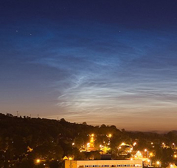
Some of the first sightings came in last night from Ireland of these electric-blue clouds that float on the edge of the atmosphere. These are sometimes seen as far south as Colorado.
If you see some, you can report them.
This photo is from the spaceweather.com, taken by Paul Evans from Larne, in Antrim County.
Unplug your clothes dryer, courtesy of the weather
Various statistics and comparisons with previous years are showing this year to be really dry and hot, like the warmest combined April and May on record. Fortunately, reservoirs in some parts of the state are in good condition.
Meanwhile, dry farmed wheat production this year will be half of average, at about 50 million bushels. The average is 100 million. One farmer speculates that Colorado is in a 23 year drought cycle. No quote on when it started and when it will end.
The Rocky covers a new forecast from the Rocky Mountain Area Coordination Center that ups the fire danger ante. Some reasons for the heat and dry conditions:
•“Weak” to “Moderate” La Niña conditions were declared in the eastern tropical pacific by late fall/early winter. The fall/winter precipitation patterns of 2005/2006 in the Rocky Mountain Area were similar to past La Niña events. Though there are some lingering atmospheric features from this year’s La Niña, current El Nino Southern Oscillation (ENSO) conditions and forecasted indices suggest neutral conditions through the end of 2006. Therefore, ENSO is expected to have little if any impact on the RMA climate during the summer of 2006.
• The North Atlantic Oscillation (NAO) (defined by the difference between high pressure from the eastern sea board into south-central Europe versus low pressure over Iceland) was negative during the winter months of 2006. Composite anomalies of spring and summer temperature, RH, and precipitation rates during past negative NAO events paint a very bleak (hot and dry) picture for portions of the Rocky Mountain Area this summer, especially over Colorado, Wyoming and the Black Hills.
Steve Jones, well known Boulder naturalist combined these figures, as posted on the Boulder County Nature Association Listserv nature-net
This was the 12th driest spring (March-May) in Boulder since 1895, and the
driest spring since 1974. Significantly, it was the driest spring recorded
since the weather station was moved to the new location (NIST), slightly
closer to the foothills, in 1989. I moved to Boulder in 1970, so I remember
springs like this one (see 1972 and 1974) when the grass turned brown before
the end of May, but it's been a long time since that happened, so it's
somewhat of a shock. Steve
Year March April May Total
1925 0.35 0.25 1.61 2.21
1966 0.31 1.21 0.80 2.32
1954 1.16 0.83 1.33 3.32
1963 1.81 0.15 1.37 3.33
1972 0.68 1.52 1.22 3.42
1962 0.48 0.99 1.99 3.46
1919 1.49 1.65 0.88 4.02
1930 0.88 0.99 2.17 4.04
1913 0.71 1.58 1.85 4.14
1911 0.64 2.68 0.90 4.22
1974 1.22 3.07 trace 4.29
2006 2.08 1.04 1.18 4.30
Notice we're not at dust bowl levels yet.
Friday, June 02, 2006
New fossils found near Maroon Bells
Research yielded evidence of four animal species
in the tracks around the Maroon Bells. About 90 percent of the tracks
came from Diadectes, a prehistoric creature that roamed the world 70
million years before the first dinosaurs, Small said. The species was a
tetrapod, which means it was four-legged, and a herbivore. It left
tracks about 5 inches long.
With a turtle head and a lizard
body, Diadectes had qualities of both amphibians and reptiles, Small
said. Rather than a missing link, it was an "odd mixture" remaining
after amphibians and reptiles split into two distinctive groups, he
said.
Diadectes was doomed, either through further evolution or
death of the species. It was extinct shortly after it left the tracks
near Aspen.
"They didn't leave any descendants," Small said. "They were a dead-end species."
Fossils of insects and conifer trees have also been
found in the Maroon formation since the discovery of the Diadectes
tracks. Those discoveries allowed scientists to determine that the land
that became the Maroon Bells was once much closer to the equator, when
it was part of the supercontinent called Pangea. The climate was more
like India and parts of Africa, with monsoonal rains and dry conditions.
The place near the Maroon Bells where the hundreds of tracks were found
probably wasn't a superhighway for Diadectes. Small's guess is that the
sliver of land just happened to be preserved. Tracks were likely
everywhere.
Since that discovery in 2001, Diadectes tracks have
been found in the Maroon formation near Glenwood Springs and State
Bridge. It appears the herbivore proliferated.
These dinosaurs were walking around when the Ancestral Rockies were still around.
Porcupines disappearing in the West?
Thursday, June 01, 2006
Drought and early peak flows from melt off
And the view from Vail indicates melt-off has peaked, earlier than normal. Is this related to the dust from Utah darkening the snow and making it heat up faster?
Part 2: NPR on dusting the Rockies from Utah
Wednesday, May 31, 2006
Glenwood PI on Ruedi release for CO river fish
Boreal Toad breeding program release planned for Peak 8
Tuesday, May 30, 2006
Bald Eagle Update - Eastern Colorado
Dusting the snow on the Rockies
From the HCN story:
On desert grasslands that have never seen grazing, "there’s barely any
dust production, no matter what"; the dust traps she posts in those
areas collect perhaps a tablespoon every six months. Most years, traps
in formerly grazed grasslands collect about twice as much, and
currently grazed lands collect even more, about nine times as much.
But the most dramatic differences, says Belnap, emerge during severe
drought years. While the ungrazed grasslands stay more or less the
same, formerly grazed ground produces as much as 20 times the amount of
dust as in wetter years. Currently grazed lands "just go bonkers," with
the dust traps sometimes filling faster than Belnap and her coworkers
can empty them.